火星の砂は赤かった
文字サイズの変更: | 小 | 中 |
大|
火星岩石の最初の解析
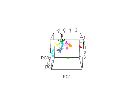
2012年9月中旬、キュリオシティは最初の火星岩石に対する本格的な解析ターゲットとして、下の岩石画像のものを選択した。レーザープラズマ光を照射し、アルファ粒子X線分析装置にかけて調べることにした。一番下の画像のように、青い三角形を正面にして、赤い印の部分を分析した。この岩石の組成元素を、3つの立体軸で3つの観測ポイントからアニメーショングラフィックで350スペクトルの異なる微細な色分け表示をしたものが一番上のもの。そして、この最初に分析を行った記念の岩石の名前を"Jake Matijevic"と名付けた。火星地表の解析エンジニアとして第一人者だったJacob Matijevic (1947-2012)の功績を称えて、NASAはそう命名した。火星の石に地球の人間の魂と生涯が、ささやかながらも宿ることになった。
Different Jake Compositions at Fine Scale
This animated graphic represents compositions indicated by 350 spectra,
or analyses of laser plasma light, observed on the rock "Jake Matijevic"
by the Chemistry and Camera (ChemCam) instrument on NASA's Curiosity rover.
Each spectrum is plotted along three axes in terms of its first three principal
components and is color coded by observation point. ChemCam analyzed 14
different points on the rock, taking 30 spectra of each point. The first
five spectra at each point were discarded because they were contaminated
by surface dust. The remaining 25 spectra from each point cluster together,
representing a unique composition for each of the 14 points. The unique
compositions indicate that individual mineral grains and combinations of
grains are observed, implying that mineral grains are in many cases larger
than the 0.014-inch (0.35-millimeter) diameter of the laser beam. In a
coarse-grained rock like Jake, the compositions of the outlier points can
then be investigated to indicate what minerals are present in the rock.
Image credit: NASA/JPL-Caltech/LANL/IRAP/UNM |
|
 |
|
|
|
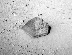
Jake Matijevic' Contact Target for Curiosity
The drive by NASA's Mars rover Curiosity during the mission's 43rd Martian
day, or sol, (Sept. 19, 2012) ended with this rock about 8 feet (2.5 meters)
in front of the rover. The rock is about 10 inches (25 centimeters) tall
and 16 inches (40 centimeters) wide. The rover team has assessed it as
a suitable target for the first use of Curiosity's contact instruments
on a rock. The image was taken by the left Navigation camera (Navcam) at
the end of the drive.
The rock has been named "Jake Matijevic." This commemorates Jacob
Matijevic (1947-2012), who was the surface operations systems chief engineer
for the Mars Science Laboratory Project and the project's Curiosity rover.
He was also a leading engineer for all of the previous NASA Mars rovers:
Sojourner, Spirit and Opportunity.
Curiosity's contact instruments are on a turret at the end of the rover's
arm. They are the Alpha Particle X-Ray Spectrometer for reading a target's
elemental composition and the Mars Hand Lens Imager for close-up imaging.
Image credit: NASA/JPL-Caltech
|
|
 |
|
|
|
Target: Jake Matijevic Rock
This image shows where NASA's Curiosity rover aimed two different instruments
to study a rock known as "Jake Matijevic." The red dots are where
the Chemistry and Camera (ChemCam) instrument zapped it with its laser
on Sept. 21, 2012, and Sept. 24, 2012, which were the 45th and 48th sol,
or Martian day of operations. The circular black and white images were
taken by ChemCam to look for the pits produced by the laser. The purple
circles indicate where the Alpha Particle X-ray Spectrometer trained its
view.
This image was obtained by
Curiosity's Mast Camera on Sept. 21, 2012 PDT (Sept. 22 UTC), or sol 46. An unannotated
version of this image is also available.
Scientists white-balanced the color in this view to increase the inherent
differences visible within the rock.
Image credit: NASA/JPL-Caltech/MSSS |
|
 |
(2012/10/18)
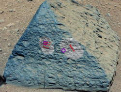
探査車キュリオシティのメカニズム
探査車キュリオシティの手足の動きとメカニズムとなる機能グラフィックスがNASAから公開されている。ドリルもあればサンプル粉末アルファ粒子のX線分光計(APXS)と掘削された火星岩石の解析装置(CHIMRA)もある。さらに虫メガネのような拡大レンズのMAHLIと埃除去装置なるDRTも装備されている。キュリオシティは5つの主要なメカニズムから構成されているわけだ。そして、採取された土壌や小石粉末のサンプルは、CHIMRAの中で下図の2つの色分け図面のように精巧な経路をたどって細分化され、緻密な分析データが得られる仕組みとなっている。こういった精密な分析装置を地球から10ヶ月もかけて火星に運び、無事に着陸後、それが今まさに現在、地道に動いて活躍し、その貴重なデータを次々に地球に送信し続けているキュリオシティは、なんて素晴らしい探査車だろう。1トンにもちかい重量の自走探査車キュリオシティがどんなにすごいか、人類の夢を実現しつつあるNASAは本当に敬服に値する。
 |
|
| Tools at Curiosity's 'Fingertips' |
| This engineering drawing shows the five devices that make up the turret
at the end of the arm on NASA's Curiosity rover. These include: the drill
for acquiring powdered samples from interiors of rocks; the Alpha Particle
X-ray Spectrometer (APXS); the sample processing subsystem named Collection
and Handling for Interior Martian Rock Analysis (CHIMRA), which includes
a scoop that can scoop up lose dirt from the Martian surface; the Dust
Removal Tool (DRT) and the Mars Hand Lens Imager (MAHLI). |
| Image credit: NASA/JPL-Caltech |
|
 |
|
 |
|
|
|
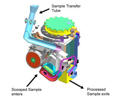
| CHIMRA: Scoops, Sieves and Delivers Samples |
|
Internal Chambers of CHIMRA |
This false-color engineering drawing shows the Collection and Handling
for In-Situ Martian Rock Analysis (CHIMRA) device, attached to the turret
at the end of the robotic arm on NASA's Curiosity Mars rover. This device
processes samples acquired from the built-in scoop (red) and the drill,
which is not shown but is also part of the turret. CHIMRA also delivers
samples to the analytical lab instruments inside the rover.
Two paths to get material into CHIMRA are shown (the scoop delivers material
to the location marked at the bottom, and the drill deposits material to
the sample transfer tube shown at top). Also marked are the location of
the vibration mechanism used to shake the turret and cause the sample to
move inside CHIMRA, and the portion box (yellow) from which the material
processed through a sieve is delivered to the analytical lab instruments.
Image Credit: NASA/JPL-Caltech | |
This cutaway view shows the internal chambers of the Collection and Handling
for In-Situ Martian Rock Analysis (CHIMRA) device, attached to the turret
at the end of the robotic arm on NASA's Curiosity Mars rover. Samples from
the drill enter via the sample transfer tube, and samples from the scoop
enter from the location shown at bottom. The pink line shows the path samples
travel from the scoop (red) to the 150-micrometer sieve (green rectangle)
to the portion box (yellow), where they are then delivered to the analytical
lab instruments.
Image Credit: NASA/JPL-Caltech |
(2012/10/12)
火星大冒険の始まり
探査車キュリオシティの火星大冒険は下の座標マップに表示されている。最初に着陸したブラッドベリー・ランディングから東の方角へ数値が進んでいるように、目的地グレネルグへと向かっている。第56地点が探査目標の一つの起点となる。第56地点から緑色の線を辿ってゆくようだ。おそらく平地から突起した岩山を避けるかのようにして、くねくねと走行してゆくのだろうか。前方監視カメラや岩石・土壌の解析カメラなどを縦横無尽に活かしながら、安全な走行でゆっくりと探査を続けている。第56地点から掘削調査ポイントまで176mと解釈すればいいのだろうか。ここに何かしらの期待と好奇が研究者らにはあるようだが。そこで10月8日にSol
62の動画撮影が公開されている。明るい地面の時間帯でロボットアームを伸ばし、制御スコップが土壌のサンプリングを掬うことで、土壌が明らかにさらさらした状態であることが確認されている。収集成分もいずれ解析されるだろう。
 |
|
Curiosity's Travels Through Sol 56
This map shows the route driven by NASA's Mars rover Curiosity through
the 56th Martian day, or sol, of the rover's mission on Mars (Oct. 2, 2012).
The route starts where the rover touched down, a site subsequently named
Bradbury Landing. The white line extending toward the right (eastward)
from Bradbury Landing is the rover's path so far, and the green line shows
its planned future route. Numbering of the dots along the line indicate
the sol number of each drive. North is up. The scale bar is 200 meters
(656 feet). By Sol 56, Curiosity had driven at total distance of about
1,590 feet (484 meters).
The Glenelg area farther east is the mission's first major science destination, selected as likely to offer a good target for Curiosity's first analysis of powder collected by drilling into a rock.
The image used for the map is from an observation of the landing site by
the High Resolution Imaging Science Experiment (HiRISE) instrument on NASA's
Mars Reconnaissance Orbiter.
Image Credit: NASA/JPL-Caltech/Univ. of Arizona |
(2012/10/09)
火星地表の古代河床の分析
火星地表に現われた古代の河床を立証する丸い小石礫岩の堆積層の画像をNASAが更新したのは、先週末のことだ。どのあたりかいえば、NASA公開の地形座標がわかりやすい。キュリオシティが火星に着陸して初めての試運転をした場所を、ブラッドベリ・ランディングと名付けられていたが、レイ・ブラッドベリはアメリカのSF作家で、今年6月5日に満91歳で亡くなっている。代表作に『火星年代記』というSF小説があるようだ。人類の文明批判を施した風刺作品で1950年に出版されている。1920年生まれで幅広い作品が多い。小説家ブラッドベリの魂はキュリオシティが代わって、本当に火星で冒険の旅をすることになった。世界中の彼の愛読者が、もしかしたら今回のNASAの火星探査をずっと見守っているかもしれない。
Curiosity's Roadside Discoveries
This map shows the path on Mars of NASA's Curiosity rover toward Glenelg,
an area where three terrains of scientific interest converge. Arrows mark
geological features encountered so far that led to the discovery of what
appears to be an ancient Martian streambed. The first site, dubbed Goulburn,
is an area where the thrusters from the rover's descent stage blasted away
a layer of loose material, exposing bedrock underneath. Goulburn gave scientists
a hint that water might have transported the pebbly sandstone material
making up the outcrop. The second feature, a naturally exposed rock outcrop
named Link, stood out to the science team for its embedded, rounded gravel
pieces. Such rounded shapes are strong evidence of water transport. The
final feature, another naturally exposed rock outcrop named Hottah, offered
the most compelling evidence yet of an ancient stream, as it contains abundant
rounded pebbles. The grain sizes are also an important part of the evidence
for water: the rounded pebbles, which are up to 1.6 inches (4 centimeters)
in size, are too large to have been transported by wind.
The image used for the map is from an
observation of the landing site by the High Resolution Imaging Science
Experiment (HiRISE) instrument on NASA's Mars Reconnaissance Orbiter.
Image credit: NASA/JPL-Caltech/Univ. of Arizona |
|

探査車キュリオシティはゴールバーンの地点から100mほど黄色矢印の方角へ移動している。緑色丸印のグレネルグを目指しているところだ。その道中で水の痕跡となる古代の河床に遭遇した。 |
|
|
|
Remnants of Ancient Streambed on Mars
NASA's Curiosity rover found evidence for an ancient, flowing stream on Mars
at a few sites, including the rock outcrop pictured here, which the science team
has named "Hottah" after Hottah Lake in Canada’s Northwest Territories. It may
look like a broken sidewalk, but this geological feature on Mars is actually
exposed bedrock made up of smaller fragments cemented together, or what
geologists call a sedimentary conglomerate. Scientists theorize that the bedrock
was disrupted in the past, giving it the titled angle, most likely via impacts
from meteorites.
The key evidence for the ancient stream comes from the size and rounded
shape of the gravel in and around the bedrock. Hottah has pieces of gravel
embedded in it, called clasts, up to a couple inches (few centimeters)
in size and located within a matrix of sand-sized material. Some of the
clasts are round in shape, leading the science team to conclude they were
transported by a vigorous flow of water. The grains are too large to have
been moved by wind.
A close-up view of Hottah reveals more details of the outcrop. Broken surfaces of the outcrop have
rounded, gravel clasts, such as the one circled in white, which is about
1.2 inches (3 centimeters) across. Erosion of the outcrop results in gravel
clasts that protrude from the outcrop and ultimately fall onto the ground,
creating the gravel pile at left.
This image mosaic was taken by
Curiosity's 100-millimeter Mastcam telephoto lens on its 39th Martian day, or
sol, of the mission (Sept. 14, 2012 PDT/Sept. 15 GMT).
Image credit:
NASA/JPL-Caltech/MSSS
|
|
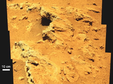
カナダのノーウェスト準州にあるハーディスティ湖にちなんで名前が付けられた火星のハーディスティ湖内、そこで見つかった浸食礫岩の露頭画像。超硬合金の岩盤がいくつも露出している。一つの拡大画像が下の画像。みんな丸く風化して見える。古代の河の底の痕跡となる。 |
|
|
|
Link to a Watery Past
In this image from NASA's Curiosity rover, a rock outcrop called Link pops
out from a Martian surface that is elsewhere blanketed by reddish-brown dust.
The fractured Link outcrop has blocks of exposed, clean surfaces. Rounded gravel
fragments, or clasts, up to a couple inches (few centimeters) in size are in a
matrix of white material. Many gravel-sized rocks have eroded out of the outcrop
onto the surface, particularly in the left portion of the frame. The outcrop
characteristics are consistent with a sedimentary conglomerate, or a rock that
was formed by the deposition of water and is composed of many smaller rounded
rocks cemented together. Water transport is the only process capable of
producing the rounded shape of clasts of this size.
The Link outcrop was imaged with the 100-millimeter Mast Camera on Sept.
2, 2012, which was the 27th sol, or Martian day of operations.
The name Link is derived from a
significant rock formation in the Northwest Territories of Canada, where there
is also a lake with the same name.
Scientists enhanced the color in this
version to show the Martian scene as it would appear under the lighting
conditions we have on Earth, which helps in analyzing the terrain.
Image credit: NASA/JPL-Caltech/MSSS
|
|
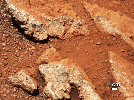
火星の古代に河で流されて来たであろう砂利サイズの丸い小石群と赤い砂。 |
|
|
|
Dry Streambed on Alluvial Fan in Northern Chile
This image shows a dry streambed on an alluvial fan in the Atacama Desert, Chile, revealing the typical patchy, heterogeneous mixture of grain sizes deposited together. On Mars, Curiosity has seen two rock outcrops close to its Bradbury Landing site that also record a mixture of sand and pebbles transported by water that were most likely deposited along an ancient streambed.
Image credit: UC Berkeley |
|
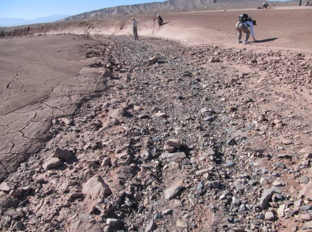
チリ北部にある標高2000mのアタカマ砂漠の扇状地は、火星の古代の河床と類似の乾いた河床を見せている。アタカマ砂漠は東西160キロ南北1000キロに及ぶ広大にして不毛の景勝地砂漠で、アンデス山脈と太平洋の間にある。 |
|
|
(2012/10/04) |
|
|
Navigator : 古川卓也 |
|
